Showing posts with label Eckley pier. Show all posts

Thursday, August 4, 2011

More Eckley pics

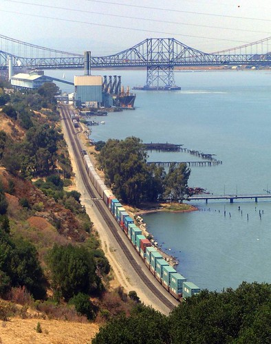
The pier again; these are the images that weren't posted on flickr.

Eckley pier

Waitin' for a train.  The stupid train actually stopped for several minutes, blocking the crossing, and it took so long to pass Eckley that two Amtrak trains passed it while I was waiting.

Kayak on the cart at the crossing

I saw other kayaks at Eckley for the first time.  I didn't get a chance to ask if they were locals or not.


Near the abandoned oil terminal upstream from Port Costa

Wharf bones near the pier

Stopped near Port Costa

Friday, July 22, 2011

Paddling at Eckley

Eckley is my new favorite place to bring the kayak.  Eckley is between Port Costa and Crockett (in Contra Costa County, California, USA, northern hemisphere, urf, etc.).  The Eckley pier is part of the Carquinez Strait Regional Park, accessible thru the Bull Valley Staging Area on the Carquinez Scenic Drive.  There's no fee for park entry.  There's lots of parking, and a few 5-minute parking slots near the pier for loading and unloading.  Eckley has a picnic area, a latrine, tap water and drinking fountains, and a popular fishing pier.  There are hiking trails in the park you can use if you don't feel like paddling, and if you need snacks or beer or bait it's a short drive to the J&L market on Pomona in Crockett.

Getting to the water requires crossing train tracks:

Don't be too casual about crossing the tracks, since Amtrak and freight trains come thru often.  The crossing is paved, so it's possible to tow a kayak on a cart over the tracks.  Be sure to consider what could happen if you drop something, or if the kayak slips off the cart, when a train is coming - the possibilities are endless, and perhaps comical, but you may as well wait for the train to pass, and then cross.

You can't launch from the fishing pier, so use the gravelly beach on the west side of the pier:

There's another gravel beach downstream that has some shade, if you don't mind carrying your gear next to the tracks for a couple of minutes.  I suspect that the water at either beach is very shallow at low tide; there's a probably-up-to-date tide table posted next to the walk at the end of the pier if you need to double-check once you're there.  When the tide's high - maybe 5' plus - there's a beach to the east of the pier, but it turns into a pile of bricks when the water level drops, and I think you'll be better off avoiding it.

Here's the pier, with Glen Cove opposite:

 Looking from the shore at the pier towards the Carquinez bridge:
The big rusty heap next to the pier is the remains of a train ferry called Garden City.  When the tide is really low you can walk thru the mud to the wreck for a photo op.  (Wear shoes, in case there is broken glass and other crap in the mud, but don't wear expensive shoes because they could get stuck.)

There were once wharves along the shore between Port Costa and Crockett, and now there are hundreds of pilings where the wharves were.  Some of these (especially upstream) may be barely submerged, so look out for those.  And I may as well mention the usual warnings for this area: watch for strong currents and high winds; look both ways before crossing the strait, so you can stay away from tugboats and shipping traffic.  You may upset the people at C&H if you get too close to their waterfront, especially when a ship is arriving or leaving  (but this area should be considered required exploring in spite of that).  It's probably best not to go near the oil terminals (upstream at Martinez and downstream at Selby) either (but that doesn't mean you can't do it anyhow).  The area near the Crockett marina, the Al Zampa bridge, the Cal Maritime campus, and Mare Island can get kind of rough when it's windy (which happens in the afternoon on most summer days).  (This might be more of a problem for those with touring kayaks than for those with modified river kayaks; I don't know, since I've never had a touring kayak.)  And the reserve fleet is off-limits, if you get that far upstream, so be careful not to get caught.


And don't forget to put your cheesy compact digital camera in a plastic bag so you can take fabulous pictures like this:
(This is the one picture that I took from the kayak that wasn't spoiled by water drops on the plastic bag.)

(And while you're there, check out the fabulous panoramic image of the park on the Regional Park signs!
I've heard that the photo credits make especially good reading!  Share and enjoy!)

Thursday, April 8, 2010

More put-ins

(This is a work in progress. Suggestions are welcome) Here are (or will be) some more potential and underdocumented places to put in kayaks and canoes. I don't have any experience paddling at these places - I don't much experience paddling at all - so take everything with a grain of salt.

American Canyon

There is a place on the Napa River a bit more that a mile north of the highway 37 bridge, and a bit less than a mile south of the remains of the USS Corry, where a residential area abuts a short slough that connects to the river. I only know this spot from the Google satellite map; I haven't had a chance to go there yet. It seems to me that if there isn't a fence there, one could park on Catalina Circle and launch in the slough next to the road. This is probably a place to avoid at low tide.

Eckley Pier

The south side of the Carquinez Strait

The Eckley pier is on the south side of the Carquinez Strait, west of Port Costa. It's accessible from the Carquinez Strait Regional Shoreline's Bull Valley Staging Area. There's a picnic area, lots of parking, and a fishing pier. There are rocky or gravely beaches on the Carquinez Strait to either side of the pier. There are hundreds of old piles from ruined wharves, and there are the remains of a side-wheel ferry.

The remains of the Garden City, and the Eckley pier

There is no boat dock. To launch here you would have to cross the train tracks (Amtrak and other trains pass frequently) and find a rock-and-pile-free spot to launch on the shore; there's a small beach next to the pier (shown in the photo above) that I think would be usable when the tide's in. The shore east of the pier is lined with rip-rap, so launching there is going to be difficult or impossible.

Conditions here are much like they are at Port Costa.


Point Pinole Regional Park

I don't think launching is allowed here, but - I think there are beaches (like the one shown below) near the north-east corner of the park that may be accessible from nearby neighborhoods.

Another San Pablo Bay beach

You can reach the beach shown above with a five-or-ten minute walk from a parking lot over asphalt and dirt trails, and over some train tracks. I'm going to go back and take another look around to see if there's street parking near there, since the little regional park parking lot tends to fill up.

Alhambra Creek

Paddlers on Alhambra Creek

Alhambra Creek becomes a tidal slough when the tide is in, and it might be possible to put the kayak in at the creek on the south edge of the Martinez Regional Shoreline, next to the Grainger's Wharf parking lot at the end of Berrellessa Street. There's a muddy bank to cope with, so it might be a better idea to hike to the small beach on the strait (near the remains of the Forester), or to launch from the marina.

There is a restroom and running water at Grainger's Wharf.

Bridge over Alhambra Creek at Grainger's Wharf


Bridge over a tiny slough adjacent to Alhambra Creek

The bridge in the picture immediately above crosses a tiny slough that joins Alhambra Creek at one end and disappears in the marshes at the other end. It seems like it ought to be possible - when the tide's in - to paddle under the bridge and a few yards up the slough, and find a spot to sit and take pictures of the birds in the tules.