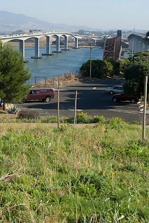
So, where do you go to get a good view? (Assuming that you don't have a boat, or access to a local oil terminal.)
This afternoon (having nothing better to do) I walked across the George Miller, Jr. Memorial Bridge (the westmost of the Martinez-Benicia bridges) to the Vista Point \ rest stop area near the north end of the bridges to scout out the good views.
 |
| Vista Point |
 |
| Vista Point, looking towards Martinez. |
On Thursday, the Vista Point area at the north end of the Benicia-Martinez bridges will have a good view of the ship being towed from the reserve fleet to the bridges, especially if you - the discriminating public that follows my blog - head up the hill at the north end of the Vista Point area.
 |
| The picnic table at the top of the hill, looking towards the reserve fleet. |
 |
| The Thingy at the top of the hill. |
When the ship reaches the first bridge it will be necessary to get to the pedestrian lane on the west-most bridge to see the Iowa being towed to the pier in Benicia. That may require five or ten minutes of walking. If that sounds like too much work, then consider the shore under the bridge; I've seen fishermen there, but I don't (yet) know how to get there, and the view there will probably be as restricted as the view from Vista Point (but you may get a better view of me in my kayak).
The ped lane on the bridge should be roomy enough to give everyone a view of the strait to the west of the bridges, but there's a fence that makes taking photos more complicated: see the next image.
 |
| View of the industrial pier (to the upper-right) from the G. Miller Jr. bridge, shot from between the bars of that stupid fence.. |
Another option, if you are one of those unlucky people without a boat, is the fishing pier at the Martinez marina. I think the view won't be very good, and if a lot of people show up, it won't be very comfortable (but there will probably be plenty of parking).
If you really want a good view, it might be best to wait until Friday, when the ship is towed to Richmond, because there will be more options. I'll put those in another blog entry.

Hey Ted, CharsShots from Flickr. I was right there yesterday (Wednesday) myself, scoping it out! You got some great shots. I was put off by the chain link fence but didn't think to walk higher up the hill, duh! I think you found a great spot for landlubbers to view it. I went down to the shoreline where you saw the fishermen. That was an interesting view also if we can get there on the Big Day (Greg thought they might close the road that goes along there). Follow Bayshore Road (if it's open) all the way to the end, where the guard gate is and you have to stop. There's a small parking lot there, outside the gate. You can walk along that side of the road till it narrows, then cross the street and walk along the other side of the road till you clear a guard rail. After that, you're right down at the water's edge (right underneath the train bridge). That's where I met several fishermen. Maybe I'll see you there!
ReplyDeleteOh, I tried to get onto the auto pier but couldn't find any way to do it. There's a public access walk along the levee off Bayshore road further to the north than the bridges, but the view wasn't good, LOTS of grassy marsh land between the levee walk and the water.